Roatan
Ecosystems.
Classification of living zones.
The area around Roatan and the Bay Islands is considered to be a Tropical Humid Forest. This area of life is restricted to narrow lowlands and covers coastal plains. The flora that integrates the vegetation of the area has characteristics and morphological features which include trees, shrubs, and grasses; as well as an evergreen, deciduous phenology.
Mangroves.
The mangroves in Roatán are distinguished by the sites they occupy, their size, and their anthropic impact. Apart from the large mangrove that stretches between its eastern extremity and Santa Elena (which is considered to be in good state of conservation) the mangrove on Roatan Island is heavily threatened by building and urban developments. This is particularly true on the western side of Roatan Island.
Garrobo.
The garrobo (Ctenosaura similis) is another example, of a native species on the Island of Roatan which depends on the local ecosystem of the mangroves and is considered Critically Endangered. Populations are on the rise and education efforts spread. Today, Roatan is one of the best places to see the Black iguana, which is a native of the Bay Islands. Gumbalimba Park offers the best place to interact and experience black iguanas.
Lagoons.
As for coastal lagoons, the island of Utila has a small lagoon and a mangrove area at the east-south-east end of the island. This area comes into contact with the main town. This intersection zone might be considered a potential conflict of interest because, on the one hand, the area offers a landscape and faunistic variety, while on the other hand, the area is a nursery for parasites (mosquitoes) at the center of this inhabited zone.
Mangrove Estuaries.
Wetlands.
Mangroves estuaries, coastal lagoons, and Mangrove wetlands are found throughout Roatan and its surrounding islands. In Utila, this type of ecosystem occupies 37% of the island's surface area. In Roatan, this type of ecosystem occupies 7.2% of the islands surface area. In Guanaja figures for this type of ecosystem drop to 6%. Utila Island, which is home to a significant portion of mangrove swamps, has a large vegetal landscape and a high level of biodiversity. This gives Utila a strong patrimonial value.
The Chachalaca.
Limited Shelter.
For example, this habitat represents a limited shelter for the Chachalaca (a tree-dwelling bird of the guan family "Ortalis vetula deschauenseei) of Utila Island. This bird subspecies is endemic to the mangroves of the island of Utila. The Chachalaca was believed to be extinct in years past but is now protected and growing.
Mangroves in Guanaja.
Hurricane Mitch.
On the island of Guanaja, mangroves were almost destroyed by the passage of Hurricane Mitch in 1998. Evaluations of the damage three years later concluded that there are few (if any) signs of natural recovery. Reforestation efforts are critical in reinstating the mangrove population to their original levels. In the northern sector, however, known as Mangrove Bight there are significant remnants. Some mangroves, although covering small areas, occupy very strategic sites such as basins with strong slopes, a proximity of notable reefs, shore of sensitive lagoons, and neighborhoods with polluted urban areas, etc. In these areas, the mangroves have a very important function and value. The presence of Mangroves in these areas can reduce the vulnerability of these coastal landscapes and allow for robust ecosystems, particularly around coral reefs.
Coastal Lagoons.
Pros and Cons.
As for coastal lagoons, the island of Utila has a small lagoon and a mangrove area at the east-south-east end of the island. This area comes into contact with the main town. This intersection zone might be considered a potential conflict of interest because, on the one hand, the area offers a landscape and faunistic variety, while on the other hand, the area is a nursery for parasites (mosquitoes) at the center of this inhabited zone.

Marine
Ecosystems.
Queen Snail (Caracol).
Within the species of marine fauna which are strongly associated with the marine grasses, the Queen Snail (Strombus gigas) is among the most dependent on a healthy seagrass pasture and ecosystem. The size of the shells for this particular mollusk left behind by fishermen gives us insight into the pressures exerted on this species in the absence of a robust seagrass coverage. The reduction of pasture areas threatens the survival of this and other mollusk species.
Seagrass Ecosystem.
Sea Grass Seagrasses develop mainly at shallow depths. Growth ranges from a few decimeters up to 2 or 3 meters in lagoons, in the depressions behind the reefs and the bottoms of bays. Seagrass grows in sectors near the coast or in areas bordered by mangroves with generally sandy-muddy to muddy bottoms. Seagrass pastures cover most of these plateaus. Tortoise Grass (Thalassia testudinum) and Manatee Pastures (Syringodium filiforme) are two of the main species of seagrass found in Roatan, Guanaja, & Utila. In most cases in mixed formation, which indicates an instability of the environment or ecosystem. This instability could be attributed to the narrowness of the continental plateau and the particularly abrupt nature of the slope of the external reefs. Little seagrass is found outside the coral reefs. This varied coastal position makes the seagrass vulnerable to anthropic attacks and makes the fragile ecosystem vulnerable in the face of the economic development of the island or Roatan.
Seagrass in Utila.
The development of seagrass is more limited in Utila than in the other Bay Islands. This is due in part to the weak development of onboard reefs that do offer sufficiently wide sedimentary plateaus for the development of seagrass. The seagrasses in Utila are found on the sandy bottoms of Turtle Harbor, Rock Harbor, Carrie's Bay, Utila Town Bay and in large plateaus of barrier reefs to the southwest of the island of Utila.
Seagrass in Guanaja.
Seagrass can also be found in front of the populated areas of Mangrove Bight and North East Bight on the Island of Guanaja. This area has sandy bottoms covered by marine phanerogams. Seagrass occupies a considerable area in the waters around Guanaja Island. In Guanaja, almost all of the island's onboard and barrier reefs are covered by pastures.

Coral Reef
Population.
Honduran Coral Reef.
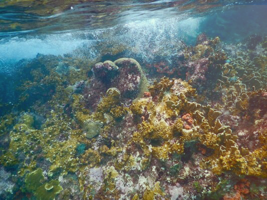
The coverage of coral reefs in Honduras amounts to at least 1120 km2. The concentration of coral reefs in Honduras is found mostly around the Bay Islands. These ecosystems are highly diverse and productive areas which bring socio-economical benefits to Honduras. Coral reefs constitute one of the most fragile and sensitive organisms which can be impacted by human activities.
The Bay Islands have diversified coral reefs with almost all the known reef morphologies. The variety of these habitats made it possible for a rich and varied flora and fauna ecosystem to thrive in Honduras.
Utila:
The barrier reef that extends to the west of the island
The coastal sector comprising Turtle Harbor and Rock Harbor
Roatán:
The reef of Cordelia Bank (submerged barrier in front of the airport)
The West End reef complex, including West End Point
Exterior slope and wall between Coco View and First Bight
The reefs from Milton Bight to Punta Blanca
The eastern part of Roatán: Santa Elena and Barbareta
Guanaja:
The reefs along the West End and Blue Rock Point
Reefs around South West Cay
The reefs around Half Moon Cay and Kiatron's Cay
Reefs stretching from Black Rock Point to East End
Population.
The maximum biodiversity of coral communities is found in the outer slopes at a depth of 10 to 20 m. The depth provides the optimal conditions of illumination and agitation (the two main ecological factors that control the settlement of corals). On the protected shores (southern coast of Roatan and Guanaja) fragile coral formations (Agaricia Tenuifolia, Acropara cervicornis) dominate the coral community of the outer slopes and Morphological structures.
Health.
Unique coral formations are found on the southern coast of Roatan Island. Coral reefs in this area have been protected from bleaching because of high currents which appear to favor a constant cleaning of excess nutrients and other contaminants coming from the largest developments on the Roatan Island. The three coral banks that make up the Bank area of Cordelia have large extensions of deer horn (Acropora cervicornis) coral. This species of coral has seen nearly three decades of massive mortality around the Caribbean. However, Cordelia Banks shows signs of being amongst the last large population site of A. Cervicornis. These banks are a source of propagules (coralline larvae) with the potential to repopulate the regional communities in the region.
Banco Cordelia.
Banco Cordelia's coverage also shows high rates of living coral. These numbers are estimated to be at 70% above of the regional average. However, this area is a singularity and not reflective of the rest of the reef population in this area. Human activities directly threaten an estimated 34% of reefs in or around Honduras. This ecological sensitivity refers to the reflection of the intrinsic characteristics of the environment (e.g., biodiversity, an abundance of populations and the value of the surrounding landscape) and their ability to withstand alterations and resisting stress (resilience). For each of the islands, the following sectors are of particular interest in the preservation of coral reefs.
Geomorphological and Ecological.
Each of the above mentioned areas contains most of the geomorphological and ecological units which have been found in the Bay Islands. In fact, they possess a great diversity of biotopes (sandy bottoms, pastures, plateaus coral, external slopes) as well as fauna and flora leafy.
The dynamics of these ecosystems and their impact on Roatán Marine Reserve show that there is indeed an effect significant in the abundance of fish and that the protected area is more abundant in large fish (biomass> 700 g) than in other areas.


